
OUT-OF-CORE CONSTRUCTION AND 3D VISUALIZATION OF
LEVEL-OF-DETAIL TERRAINS POPULATED WITH LARGE
COLLECTION OF HETEROGENEOUS OBJECTS
Anupam Agrawal, M. Radhakrishna
Indian Institute of Information Technology (Deemed University), Deoghat, Jhalwa, Allahabad – 211 012, India
R.C. Joshi
Dept. of Electronics & Computer Engg., Indian Institute of Technology, Roorkee – 247 667, India
Keywords: Terrain visualization, Out-of-core algorithms, Multiresolution modeling, View-dependent refinement.
Abstract: Interactive visualization of very large-scale terrain data in scientific visualization, GIS or simulation and
training applications is a hard problem. The grid digital terrain elevation and texture data are not only too
large to be rendered in real-time but also exceed physical main memory capacity. Therefore out-of-core
management of digital terrain data is an essential requirement. Further to bring photorealism in
visualization, it is required to place multiple collections of man-made objects such as buildings, lampposts
etc. as well as natural objects such as trees, grass etc. on top of the terrain surface. In this paper we have
proposed an integrated approach for effective out-of-core visualization of terrains populated with large
collection of static heterogeneous objects. We have developed an efficient tile-based out-of-core view-
dependent Level of Detail (LOD) mesh simplification algorithm for real-time rendering of large terrains.
Instead of manipulating individual triangles, the algorithm operates on clusters of geometry called blocks of
aggregate triangles. Hence the amount of work CPU must perform is greatly reduced. The formation of long
triangle strips for LOD blocks also solves the CPU-to-Card bandwidth problem. The tile-based
multiresolution terrain geometry framework has been extended to support large satellite or aerial imagery
textures. To display large collection of objects over the terrain while maintaining the real-time frame rate,
an efficient object handling method has been proposed using paging technique and object instantiation. User
is allowed to control the objects locations, scales and orientations. The algorithms have been implemented
using Visual C++ and OpenGL 3D API and successfully tested on different real-world height maps and
satellite phototextures of sizes upto 16K*16K coupled with thousands of static objects on PCs.
1 INTRODUCTION
There is a growing demand for high quality
interactive visual simulations in the field of
landscape visualization. However, interactive
visualization of large-scale terrain data brings up a
wealth of problems. Because the grid digital terrain
models are not only too large to be rendered in real-
time but also exceed physical main memory
capacity, traditional in-memory multiresolution
meshing and rendering techniques do not provide a
sufficient solution. Relying only on virtual memory
and the operating system’s paging mechanism does
not sufficiently take into account spatial as well as
level-of-detail relations in a multi-resolution
triangulation framework. For rendering large terrain
from out-of-core, the multi-resolution data structure
and rendering algorithm themselves must provide an
efficient paging of LOD data from disk. The same
argument holds true for rendering large collection of
static heterogeneous objects such as buildings, trees
etc. on top of the terrain surface.
To achieve real-time rendering without
sacrificing accuracy, several aspects have to be
considered. On one hand, to exploit the full
performance of the current Graphics Processing
Units (GPUs) hardware, transmission of large data
chunks is advantageous. On the other hand, no
unnecessary data should be submitted for rendering,
since bandwidth and I/O are often the bottleneck of
429
Agrawal A., Radhakrishna M. and Joshi R. (2006).
OUT-OF-CORE CONSTRUCTION AND 3D VISUALIZATION OF LEVEL-OF-DETAIL TERRAINS POPULATED WITH LARGE COLLECTION OF
HETEROGENEOUS OBJECTS.
In Proceedings of the First International Conference on Computer Graphics Theory and Applications, pages 429-435
DOI: 10.5220/0001358404290435
Copyright
c
SciTePress

current graphics systems. Furthermore, with the
growing GPU power the management of fine-
grained LODs on the CPU as done by traditional
algorithms (Lindstrom, 1996, and Duchaineau,
1997) becomes more and more limiting factor, and
in many rendering applications the GPU is not
working at full capacity.
This paper discusses the methodology and
implementation aspects of our research work to
improve the quality and speed of rendering of large
terrains with objects on general-purpose desktop
PCs. Our block-based dynamic LOD terrain-
rendering software, TREND, considers above facts
using 3D rendering hardware and minimizes the
CPU overhead. We have proposed an integrated
approach for effective out-of-core visualization of
terrains populated with large collection of discrete,
static heterogeneous objects. User is allowed to
control the objects locations, scales and orientations.
The object instantiation scheme reduces the memory
overhead to a large extent.
2 RELATED WORK
External memory algorithms (Vitter, 2001), also
known as out-of-core algorithms, address issues
related to the hierarchical nature of the memory
structure of modern computers (fast cache, main
memory, hard disk etc.). Managing and making the
best use of the memory structure is important when
dealing with large data structures that do not fit in
the main memory of a single computer. In most
terrain visualization systems, two approaches are
prevailing for external memory handling. In the first
approach (Dollner, 2000, and Lindstrom, 2001) the
multiresolution terrain triangulation hierarchy is
linearized into an array and a memory-mapped file
mechanism (supported by the operating system) is
used to provide out-of-core access. The second
approach (Reddy, 1999, and Pajarola, 1998) is to
split the terrain into large rectangular tiles of varying
resolution that are paged in on demand. The main
drawbacks of the first approach are that the terrain
data is only clustered on disk with respect to the
linearization of the triangulation hierarchy and that
the storage cost is comparatively high. We have
adopted the second approach for out-of-core data
management for terrain topography as well as for the
objects.
Many mesh simplification and multiresolution
triangulation methods have been developed over the
last decade. Due to space constraint, we refer to the
literature for overviews on general mesh
simplification and multiresolution modelling
(Cignoni, 1998, and Luebke, 2001). We have chosen
regular hierarchical structure to represent terrain
(stored as height map) as it allows fast collision
detection between moving objects (including
camera) and the terrain. It also supports use of
efficient hierarchical data structures for fast and easy
view frustum culling.
Relatively less work has been reported in
literature on object management over
multiresolution terrain. Szenberg et al. (Szenberg,
1997) describe a method of terrain visualization with
point-location based objects such as houses,
transmission poles etc. The visualization scheme for
terrain height field is not based on multiresolution
modelling but combines the Z-buffer with the
Floating Horizon algorithm. Further it has been
applied to limited sized terrain data (512*512 size)
only. Douglass et al. (Douglass, 1999) describe a
bottom-up LOD height-field rendering scheme by
placing building-like objects over the terrain. In
contrast to a top-down LOD approach, a bottom-up
approach necessitates the entire model being
available at the first step and therefore has higher
memory and computational demands (Luebke,
2003). In this paper, we have proposed a new object
management approach coupled with our block-based
multiresolution LOD terrain modelling approach. It
employs an efficient object-paging scheme, which
smoothly adapts to our tile-based organization of
geometry and texture data for out-of-core data
management.
3 THE TILE BASED MULTI-
RESOLUTION FRAMEWORK
We have developed a view-dependent dynamic
block-based LOD modelling for mesh simplification
and using tiled geospecific texture, to display the
details of the high-resolution satellite imagery in
real-time rendering (Agrawal, 2004a). The terrain
geometry and texture data are organized in titles of
size 257*257 and 256*256 respectively as shown in
Figure 1. One pixel overlap is kept between adjacent
geometry tiles to ensure proper stitching of tiles. At
any instance of time, only nine tiles are kept in main
memory. The viewer position is always assumed to
be inside the centre tile. The algorithm efficiently
handles out-of-core data by dynamic paging of
terrain tiles between secondary storage and main
memory. Each geometry tile data is organized with a
quadtree with leaves corresponding to patches or
GRAPP 2006 - COMPUTER GRAPHICS THEORY AND APPLICATIONS
430
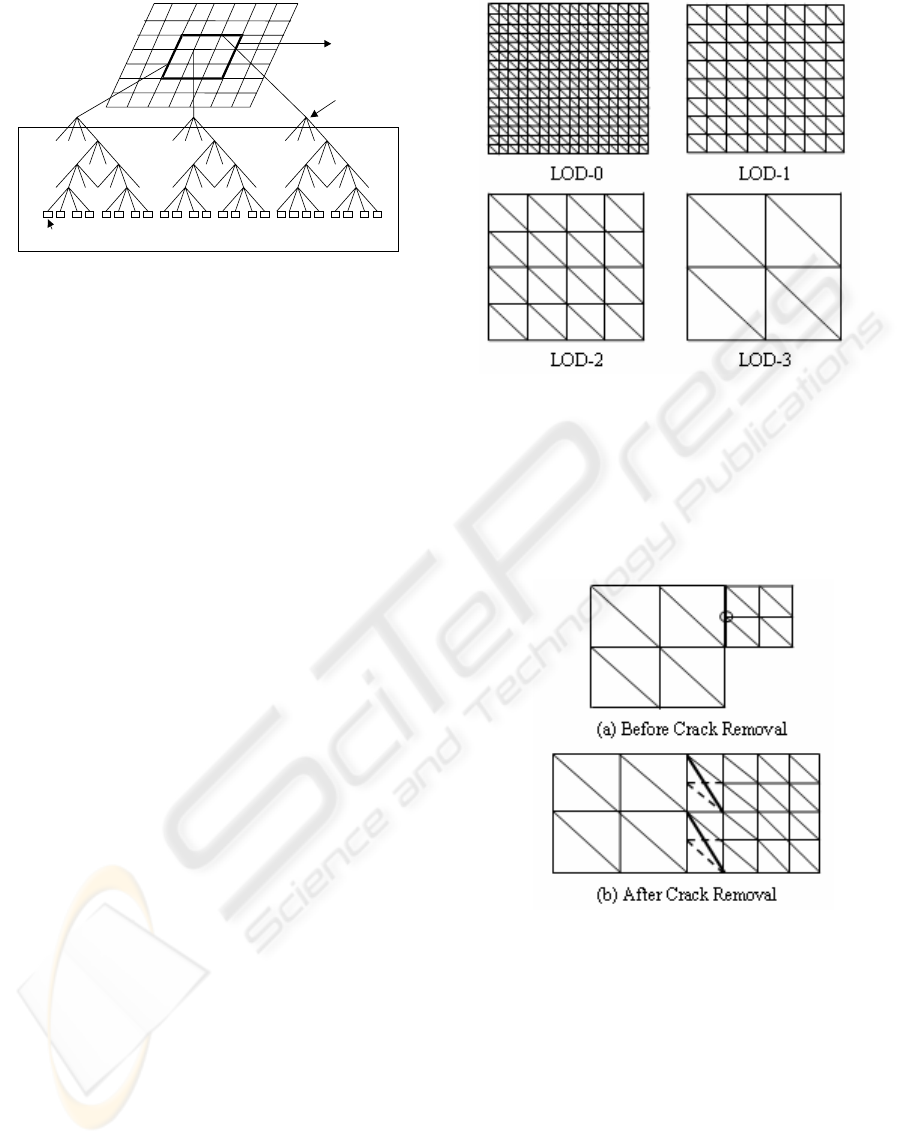
blocks of size 17*17 (the size decided after
experimentation) to speed up the view-frustum
culling.
Multiresolution pyramid representation is used
to define each terrain block. Figure 2 shows the four
pyramid levels of the height map block of size
17*17. Considering the multiresolution
representation for each patch, the algorithm employs
a variable screen-space threshold
(τ) to limit the
maximum error of the projected image considering
the terrain complexity, viewer distance and viewing
direction as the viewer navigates the terrain. The
algorithm pre-computes a look-up table at terrain tile
load time to decide the tessellation level of each
block within view-frustum based on position of the
camera from the block (De Boer, 2000). In the
approach, a group of vertices are considered instead
of single vertex for deciding whether to remove
them or not. Hence CPU requirements are many
times lower as compared to the LOD mesh
simplification algorithms, which work on individual
vertices of the height field.
It is important to note that in a view-dependent
framework, the resolution of adjacent patches might
change at every frame. Hence, cracks occur on
borders of adjacent patches of different levels of
detail. In Figure 3 (a), the circle shows the position
of crack in tessellation with level difference one
(right side patch is shown partially). Figure 3 (b)
shows the modified geometry to remove the cracks
where the dashed edges are excluded in triangulation
and the bold edges are included. Similar procedure is
followed to eliminate cracks when level difference
between adjacent patches is two or three. Image
draping over 3D mesh geometry is performed using
texture mipmapping. The algorithm also handles the
problem of texture seams between adjacent texture
tiles (Agrawal, 2004b).
Figure 2: Multiresolution Modelling of Height Map.
To exploit the full performance of current GPUs
hardware, transmission of large data chunks is
advantageous. Graphics rendering can be accelerated
through compact representations of polygonal
meshes using data structures such as triangle strips
and triangle fans. Using triangle strip primitive, it is
possible to form a longer length of connected
Figure 3: Removing Cracks between Adjacent Patches.
triangles as compared to triangle fan. Generating
long triangle strips efficiently solves the CPU-to-
card bandwidth problem and avoids redundant 3D
vertex transformation and lighting (T&L)
calculations. However in view-dependent meshing
methods the underlying mesh is in a constant state of
flux between view positions. This poses a significant
hurdle to construct long triangle strips. Our triangle
strip generation scheme for view-dependent dynamic
multiresolution terrain shows significant
improvement in rendering speed as compared to
individual triangle-based and triangle-fan based
rendering schemes (Agrawal, 2005). The snapshot of
Size of leaf block: 17*17
(used for LOD management)
Memory: 3*3 block
s
(block size: 257*257
)
Four Level Quadtree
Containing Terrain
Polygon
s
Figure 1: Organization of Terrain Geometry Data.
OUT-OF-CORE CONSTRUCTION AND 3D VISUALIZATION OF LEVEL-OF-DETAIL TERRAINS POPULATED
WITH LARGE COLLECTION OF HETEROGENEOUS OBJECTS
431
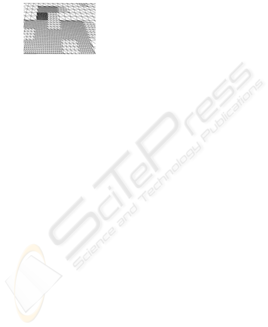
the triangulated height map is given in Figure 4
using triangle-strip primitive.
Figure 4: Wireframe View of Terrain LOD Geometry.
4 OUT-OF-CORE
VISUALIZATION OF OBJECTS
We may divide the point-location objects into two
categories. The first one is simple objects, those
having simple geometry and can be drawn with the
help of OpenGL primitive functions. These objects
do not need to be loaded into memory. Examples of
simple objects include sky-scrapper buildings drawn
using elongated cube with texture mapping over its
exposed faces and also objects created using
billboarding technique. The second category is of
complex objects having complex geometry and large
number of triangles. These objects are required to be
loaded into main memory containing their vertices
and topology information. Examples of such objects
include complex 3D geometrical models of
buildings, trees etc. The software has the provision
to import such complex structures from .dxf format
and convert into native .mesh files obtained after
selecting relevant only information. Complex
objects may consume substantial memory as well as
drawing time and may severely affect the rendering
performance. So we usually prefer to use simple
objects to populate the terrain.
While having a walkthrough over the 3D terrain,
user cannot see all the objects at once. Thus there is
no need of keeping all of them in memory and
render them. Our objective is to deal with large
number of objects over the terrain. The number of
objects is not constant throughout the navigation
process; also more objects can be edited, added, or
even deleted from the objects list. To enable real-
time rendering and interactive communication
between user and objects, an efficient method of
object handling has been proposed and implemented
using dynamic paging technique and object
instantiation.
4.1 Placing Multiple Instances of
Objects over Terrain
The first task has been the deployment of various
building-like objects on the terrain. The various
types of buildings and houses being rendered on the
terrain would give a look of a good human
settlement. The software has the provision for
various types of buildings like clock-towers,
skyscrapers, houses etc to be shown on the terrain.
The buildings could be designed using OpenGL 3D
API itself or using AutoCAD package (in DXF-
3DFACE format). The software helps the user to
place a building anywhere on the terrain by pointing
at the scanned georeferenced map or image in the
background inside a 2D window after selecting the
specific building model. Once the buildings are
deployed on the terrain, the software permits the
user to edit the objects using all the conventional
edit features for the objects such as scale change etc.
An object may have its multiple instances with
possibly different scaling factors. If an object is
already been loaded into memory, on its subsequent
occurrences simply the pointer of object memory is
returned for further processing and its counter is
incremented by one. Thus the multiple loading of
same objects can be avoided.
For many objects and a few special effects such
as storm etc. we have also used the technique of
billboarding which is sometimes of great use as the
loss in framerate is quite negligible and it displays
the 2D images just like 3D objects. Billboarding is a
technique that adjusts an object's orientation so that
it "faces" some target, usually the camera.
Billboarding can be used to cut back on the number
of polygons required to model a scene by replacing
geometry with an impostor texture. For example
this technique has been used to create trees,
lampposts, signposts etc. This particular technique
can be used in these cases when finer detail is not
required about the object. Here we have used small
size .bmp or .tga images to use as textures, which
take less space and hence help us in achieving a
better frame rate i.e. faster rendering of the terrain
with objects. Only object’s memory reference and
new scaling factors are kept in memory for multiple
instances of same object.
GRAPP 2006 - COMPUTER GRAPHICS THEORY AND APPLICATIONS
432
4.2 Paging and Display of Objects
When user opens the model layer consisting of
objects, a message is sent to Objects class to open
the particular file, followed by loading of names and
locations of all the objects, which are there in file.
These all objects (i.e. their geometry & texture) are
not loaded into memory, but the objects of same tiles
are grouped together, so that objects of current nine
tiles can be loaded into memory. The software
internally manages a dynamic data structure to store
tile-wise objects details (without their geometry &
topology information). The geometry & topology
information of only those complex objects are kept
in main memory, which are inside current active
nine tiles.
When new tiles are loaded and old are deleted,
‘AddModel’ function is called to add new models
and ‘RemoveModel’ is called to remove old models
of corresponding tiles. The ‘AddModel’ function is
called prior to ‘RemoveModel’ function to optimize
the time. The model is deleted from the linked-list in
memory only when there is no instance of same
model in current scene. Otherwise counter is
incremented or decremented accordingly. Objects
paging helps in out-of-core management of large
objects data on secondary storage.
5 RESULTS AND DISCUSSION
The software TREND has been tested with 2K*4K
terrain raster dataset of Grand Canyon and 16K*16K
terrain data set of Puget Sound area obtained from
Georgia Institute of Technology website. We have
also generated the height map of Dehradun (India)
area using digitised contours on Survey of India
(SOI), India supplied topographic map. The
corresponding geo-referenced IRS-1D FCC Satellite
imagery has been used for image draping.
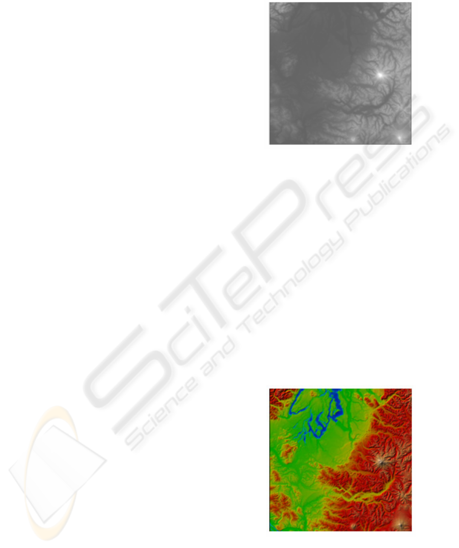
The images in Figure 5 and Figure 6 show the
Height map (DEM) of Puget Sound area and
corresponding False Color Composite Satellite
imagery respectively.
Figure 7 and Figure 8 show the level of detail 3D
wiremesh view and corresponding phototextured
view respectively. Figure 9(a) shows a view with
point-location based simple objects (OpenGL and
Billboard drawn objects). A complex object (a
building designed using AutoCAD) is shown over
the terrain in Figure 9 (b).
The performance of the software has been
evaluated on a Pentium IV 2.4 GHz computer with
512MB RAM and Intel 82865G onboard Graphics
Controller on 865GL motherboard. The performance
of the algorithm on raster data is independent of size
of terrain data as with the tiles indexing scheme, the
Figure 5: DEM (Height Map) of Puget - Sound area (size
16K*16K).
algorithm only keeps nine tiles active in main
memory. The organization of the terrain data in tiles
of defined size is required to be done only once on
the same data set. For raster data, the number of
frames rendered per second mainly depends on the
complexity of the terrain (roughness) under the
view-frustum and the user defined image quality
metric (τ). The graphs in Figure 10 show the effect
of τ on rendering performance. Table 1 shows
performance analysis of the Adaptive LOD
Algorithm for 3D visualization of the raster data set.
The results of testing the same adaptive LOD
algorithm using triangle strip (with indexed vertex
array) in conjunction with object management
algorithm are shown in Table 2. The value of τ is
kept 4.0 to obtain various results as shown in Table
1 and Table 2.
Figure 6: FCC Satellite Imagery of Puget - Sound area
(size 16K*16K).
OUT-OF-CORE CONSTRUCTION AND 3D VISUALIZATION OF LEVEL-OF-DETAIL TERRAINS POPULATED
WITH LARGE COLLECTION OF HETEROGENEOUS OBJECTS
433

6 CONCLUSION AND FUTURE
WORK
This paper discusses the methodology and
implementation aspects of our research work to
improve the quality and speed of rendering of large
terrains on general-purpose desktop PCs. The proposed
LOD algorithm for raster data uses a compact and
efficient multi-resolution grid representation of height
fields and employs a variable screen-space threshold to
limit the maximum error of the projected image. The
method is different from the individual triangle-based
LOD algorithms and is optimised for modern,
consumer 3D graphics cards and minimizes CPU usage
during rendering. It is augmented with out-of-core
visualization of large height geometry and texture
terrain data. To display large collection of point-
location based static objects over the terrain while
maintaining the real-time frame rate, an efficient
object handling method has been proposed using
paging technique and object instantiation. Objects
include different kinds of buildings, trees etc. User is
allowed to control the objects locations, scales and
orientations.
As a next step to further improve the rendering
performance and quality of visualization, we are
currently investigating rendering using state-of-the-
art programmable GPU cards through vertex and
fragment programs. Complex 3D objects such as
buildings and trees with large number of polygons,
severely affect the rendering performance. Discrete
multiresolution representation of these objects and
their run-time selection may further increase the
rendering speed.
REFERENCES
Agrawal, Anupam et al., 2004a. TREND: Adaptive Real-
time View-dependent Level-of-detail-based Terrain
Rendering. Proceedings IT++: The Next Generation -
the 39
th
Annual National Convention of Computer
Society of India (CSI) held in Mumbai, pp. 146-157.
Agrawal, Anupam et al., 2004b. Dynamic Multiresolution
Level of Detail Mesh Simplification for Real-time
Rendering of Large Digital Terrain Models.
Proceedings IEEE India Annual Conference 2004
(INDICON-2004) at IIT, Kharagpur, pp. 278-282.
Agrawal, Anupam et al., 2005. An Approach to Improve
Rendering Performance of Large Multiresolution
Phototextured Terrain Models using Efficient Triangle
Strip Generation. Paper presented in IEEE IGARSS-
2005 held in Seoul, Korea during July 25-29, 2005.
Cignoni, P. et al., 1998. A Comparison of Mesh
Simplification Algorithms. Computers and Graphics,
22(1), pp. 37-54.
De Boer, W. H., 2000. Fast Terrain Rendering Using
Geometrical MipMapping. http://www.flipcode.com/
articles/article_geomipmaps.pdf.
Dollner, J. et al., 2000. Texturing Techniques for Terrain
Visualization. In Proceedings of IEEE
Visualization’2000, pp. 207-234.
Douglass, D. et al., 1999. Real-Time Visualization of
Scalably Large Collections of Heterogeneous Objects.
In Proceedings of IEEE Visualization‘99, pp. 437-440.
Duchaineau, M. et al., 1997. ROAMing Terrain: Real-time
Optimally Adapting Meshes. In Proceedings of IEEE
Visualization’97, pp. 81-88.
Lindstrom, P. et al., 1996. Real-Time Continuous Level of
Detail Rendering of Height Fields. In Proceedings of
ACM SIGGRAPH’96, pp. 109-118.
Lindstrom, P. and Pascucci, V., 2001. Visualization of
Large Terrains made easy. In Proceedings of IEEE
Visualization’2001, pp. 363-370.
Luebke, D., 2001. Survey of Polygon Simplification
Algorithms. IEEE Computer Graphics and
Applications, 21(3), pp.24–35.
Luebke, D. et al., 2003. Level of Detail for 3D Graphics,
Morgan Kaufmann Pub., pp. 19-46.
Pajarola, R., 1998. Large Scale Terrain Visualization
using the Restricted Quadtree Triangulation. In
Proceedings of IEEE Visualization’98, pp. 19-26.
Reddy, M. et al, 1999. TerraVision II: Visualizing
Massive Terrain Databases in VRML. IEEE Computer
Graphics & Applications, Vol. 19(2), pp. 30-38.
Szenberg, F. et al., 1997. An Algorithm for the
Visualization of a Terrain with Objects. In X Brazilian
Symposium on Computer Graphics and Image
Processing, pp. 103-110.
Vitter, J.S., 2001. External Memory Algorithms and Data
Structures: Dealing with Massive Data. ACM
Computing Surveys, Vol. 33, Issue 2, pp. 209-271.
Table 1:Performance Analysis of the Adaptive LOD
Algorithm (without Objects).
Terrain Rendering
(without objects)
Avg. no. of
Triangles
Avg.
Frame per
Second
Full resolution
(considering 9 tiles
only)
1327104.00 01.63
View frustum culled
surface
268338.82 05.96
Adaptive LOD
algorithm (τ=4)
1. Using triangle list
2. Using triangle fan
3. Using triangle strip
(without using
indexed vertex array)
4. Using triangle strip
(with using indexed
vertex array)
16764.25
16764.25
19763.86
19752.95
58.63
76.47
112.65
128.89
GRAPP 2006 - COMPUTER GRAPHICS THEORY AND APPLICATIONS
434
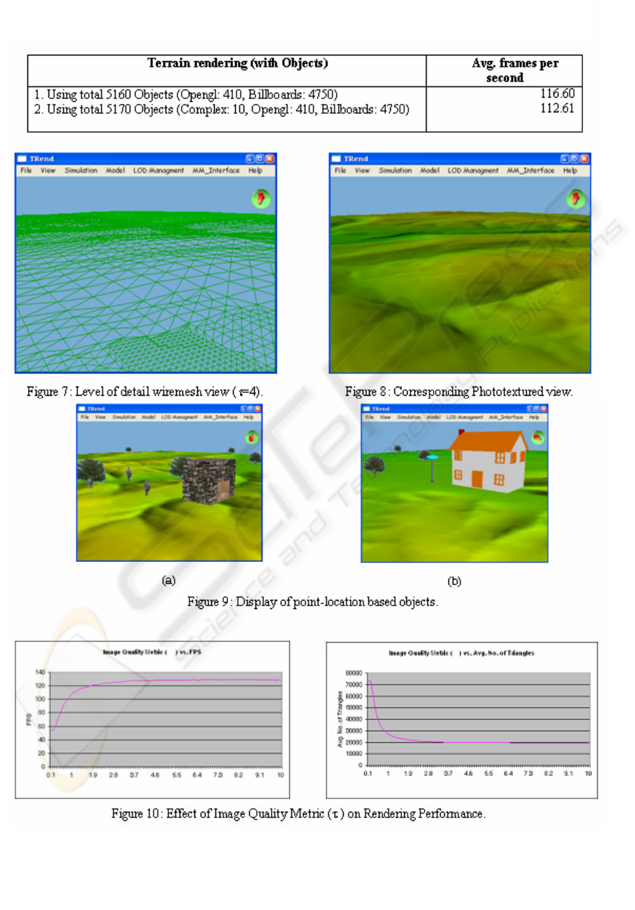
Table 2: Performance Analysis of the Adaptive LOD Algorithm (with Objects).
OUT-OF-CORE CONSTRUCTION AND 3D VISUALIZATION OF LEVEL-OF-DETAIL TERRAINS POPULATED
WITH LARGE COLLECTION OF HETEROGENEOUS OBJECTS
435
