
GEOSPATIAL PUBLISHING
Creating and Managing Geo-Tagged Knowledge Repositories
Arno Scharl
Know-Center & Graz University of Technology,
Knowledge Management Institute; Inffeldgasse 21a, 8010 Graz, Austria
Keywords: Geospatial Web, Geo-Tagging, Content Production, Knowledge Acquisition.
Abstract: International media have recognized the potential of geo-browsers such as NASA World Wind and Google
Earth, for example when Web and television coverage on hurricane “Katrina” used interactive geospatial
projections to illustrate its path and the scale of destruction. Yet these early applications only hint at the true
potential of geo-browsing technology to build and maintain virtual communities, and to revolutionize the
production, distribution and consumption of media products. Investigating this potential, this paper reviews
the literature on geospatial publishing with a special focus on extracting geospatial context from unstruc-
tured textual resources. A content analysis of online coverage based on a suite of text mining tools then
sheds light on the popularity and adoption of geo-browsing platforms. While such platforms might help en-
rich a company’s portfolio of media products, they also pose a threat for existing players through attracting
new competitors; e.g., independent providers of geospatial metadata or location-based services.
1 INTRODUCTION
Contrary to early predictions of the Internet render-
ing geography irrelevant, the discipline is increas-
ingly gaining importance. Geo-browsers facilitate
the access to vast quantities of geo-referenced and
time-stamped data. Keen competition between well-
known software and media companies surrounds the
provision of two-dimensional geospatial user inter-
faces. Google Maps (maps.google.com), MapQuest
(www.mapquest.com), MS Virtual Earth (Windows
Live Local; local.live.com), Yahoo Local Maps
(maps.yahoo.com) and other online services are add-
ing new functionality, data sources and interface
options in rapid succession. These tools transmit
cartographic data and visualize the context and geo-
graphic distribution of different types of location-
based resources and services.
Three-dimensional geo-browsers combine satel-
lite i
magery with aerial photographs and Shuttle
Radar Topography Mission (SRTM) elevation data.
Using standardized services such as the bitmap-
based WMS (Web Mapping Service) or the vector-
based WFS (Web Feature Service) of the Open Geo-
spatial Consortium (www.opengeospatial.org), im-
age tiles and vector data including geo-positioning
information are retrieved from a central server, ar-
ranged into a real-time mosaic, and mapped onto a
three-dimensional representation of the globe. Alter-
ing the field-of-view angle allows to zoom in and
out on Earth and increase or decrease the level of
detail displayed. Users can seamlessly zoom from
NASA Blue Marble data at 1-kilometer-per-pixel,
for example, to the detailed mosaic of LandSat 7
data at 15-meters-per-pixel (Hogan & Kim, 2004).
Adding the option to tilt the display relative to the
spectator’s point of view adds a third dimension,
altitude. Layers built into the interface provide allow
users to effortlessly switch between detailed views
and highly aggregated representations.
Most providers of geo-browsing platforms offer
Application Programming
Interfaces (APIs) or XML
scripting to facilitate building third-party online ser-
vices on top of their platforms (Roush, 2005). Mul-
tiple layers of icons, paths and images can be pro-
jected via these services – referencing and scaling
icons, for example, positioning them on the globe,
and linking them to external knowledge repositories,
(Web) documents, or photo collections. Latitude and
longitude variables determine the symbols’ position,
while distance above surface values specify whether
symbols hover above ground. A good example is the
data from NASA’s Moderate Resolution Imaging
Spectroradiometer (MODIS), providing daily up-
dated planetary imagery, documenting natural events
such as fires and storms (Hogan & Kim, 2004).
226
Scharl A. (2006).
GEOSPATIAL PUBLISHING - Creating and Managing Geo-Tagged Knowledge Repositories.
In Proceedings of the First International Conference on Software and Data Technologies, pages 226-231
DOI: 10.5220/0001313302260231
Copyright
c
SciTePress

Traditionally, the role of geography has been re-
stricted to retrieving information more effectively
and enhancing inference operations, but not for
specification of queries and the presentation of re-
sults. Geo-browsers are about to address this short-
coming by redefining the look and feel of user inter-
faces, leveraging the knowledge about a user’s loca-
tion to unlock organized indices to the physical
world (Kendall, 2005).
2 GEO-TAGGED KNOWLEDGE
REPOSITORIES
Concentrated efforts are underway to geo-tag as
much existing information as possible. Geo-tagging
refers to the process of assigning geospatial context
information, from specific point locations to arbitrar-
ily shaped regions. Sources of geospatial context
information for annotating Web resources include:
• Annotation by the authors (Daviel & Kaegi,
2003), manually or through location-aware de-
vices such as GPS navigation systems, RFID-
tagged products and cellular handsets (Francica,
2005). These devices geo-tag information auto-
matically when it is being created.
• Determining the location of the server – e.g. by
querying the Whois database for domain regis-
trations, monitoring how Internet traffic is
routed, or by analyzing the URL for additional
cues (McCurley, 2001).
• Automated annotation of existing documents:
The processes of recognizing geographic con-
text and assigning spatial coordinates are com-
monly referred to as geo-parsing and geo-
coding, respectively (McCurley, 2001).
Once geospatial context information becomes
widely available, any point in space will be linked to
a universe of commentary on its environmental, his-
torical and cultural context, related community
events and activities, as well as personal stories and
preferences. With the widespread introduction of
commercial applications such as location-based ser-
vices and geospatial gaming environments, even
locative spam will be a common phenomenon (Erle,
Gibson, & Walsh, 2005). At present, however, many
metadata initiatives still suffer from the chicken and
egg problem of wishing that existing content was
retrofitted with metadata (McCurley, 2001). Geo-
tagging projects are no exception. Addressing this
shortcoming, this paper focuses on the third cate-
gory, the automated parsing and coding of existing
resources (online news, for example, and other types
of unstructured textual data found on the Web).
2.1 Geo-Parsing
All human artefacts have a location history, which
commonly includes a creation location and current
location (Spohrer, 1999). Depending on the avail-
ability of metadata, geospatial applications can map
the whole life cycle of such artefacts. Electronic
resources contain the required metadata as explicit
or implicit geographic references. This includes ref-
erences to physical features of the Earth's surface
such as forests, lakes, rivers and mountains, and ref-
erences to objects of the human-made environment
such as cities, countries, roads and buildings (Jones,
Alani, & Tudhope, 2001). Addresses, postal codes,
descriptions of landmarks, and annotated hyperlinks
also allow to pinpoint an exact location (Ding, Gra-
vano, & Shivakumar, 2000; McCurley, 2001).
At least 20 percent of Web documents contain
easily recognizable and unambiguous geographic
identifiers (Delboni, Borges, & Laender, 2005).
News articles are particularly rich in such identifiers,
since they generally report on the location where an
event took place, or where it was reported from
(Morimoto, Aono, Houle, & McCurley, 2003) – a
distinction also referred to as source versus target
geography (Amitay, Har’El, Sivan, & Soffer, 2004).
The BBC article “Vienna marking Mozart mile-
stone” (Bell, 2006), for example, has a target geog-
raphy of E
UROPE/AUSTRIA/VIENNA, and a source
geography of E
UROPE/UNITED KINGDOM/LONDON.
In addition to target and source geography, natural
language processing also allows extracting the geo-
graphic scope (reach) of a Web resource in many
cases (Wang, Xie, Wang, Lu, & Ma, 2005).
Identifying and ranking spatial references by
semantically analyzing textual data is a subset of the
more general problem of named entity recognition,
which locates and interprets phrasal units such as the
names of people, organizations, and places (Cowie
& Lehnert, 1996). As with most named entity recog-
nition tasks, false positives are inevitable – e.g.,
documents that quote addresses unrelated to the their
actual content (Morimoto, Aono, Houle, &
McCurley, 2003). Ambiguity, synonymy and
changes in terminology over time further complicate
the geo-parsing of documents (Amitay, Har’El,
Sivan, & Soffer, 2004; Kienreich, Granitzer, & Lux,
2006; Larson, 1996). Identical lexical forms often
refer to distinct places with the same name (V
IENNA
referring to the capital of Austria as well as a town
in Northern Virginia, US), for example, or can have
both geographic and non-geographic meanings –
e.g.,
TURKEY (large gallinaceous bird; bi-continental
country between Asia and Europe), M
OBILE (capa-
ble of moving; city in Alabama, US) and R
EADING
(processing written linguistic messages; town in
Massachusetts, US). The geo-parsing component
GEOSPATIAL PUBLISHING - Creating and Managing Geo-Tagged Knowledge Repositories
227

needs to correctly process references to identical or
similar places that may be referred to by different
names, may be at different levels of the administra-
tive hierarchy, or nearby by some measure of prox-
imity (Jones, Alani, & Tudhope, 2001).
2.2 Geo-Coding
Once a location has been identified, the content
fragments can be assigned precise spatial coordi-
nates – latitude, longitude and altitude – by querying
a structured geographic index (gazetteer) for match-
ing entries (Hill, Frew, & Zheng, 1999; Tochter-
mann, Riekert, Wiest, Seggelke, & Mohaupt-Jahr,
1997). Examples of public geographic indices are
the Geographic Names Information System (GNIS),
the World Gazetteer, the classifications of the
United Nations Group of Experts on Geographical
Names, the Getty Thesaurus of Geographic Names,
and the ISO 3166-1 Country Codes.
While simple gazetteer lookup clearly benefits
from being language-independent, more advanced
algorithms consider lexical and structural linguistics
clues, as well as contextual knowledge contained in
the documents – e.g., dealing with ambiguity by
removing stop-words, identifying references to peo-
ple and organizations (Clough, 2005), and applying
contextual rules such as “co-occurring place names
indicate nearby locations”. For each identified refer-
ence, this process assigns a probability P(name,
place) that a given name refers to a particular place
(Amitay, Har’El, Sivan, & Soffer, 2004). The inter-
pretation with the highest probability is then as-
signed a canonical taxonomy node such as
E
UROPE/AUSTRIA/VIENNA (48°14’ N; 16°20’ E).
2.3 Managing Geospatial Context
Metadata frameworks often include geospatial at-
tributes, e.g. the Dublin Core Metadata Initiative’s
“Coverage” tag (McCurley, 2001). The need for
controlled vocabularies suggests that ontologies are
going to play a key role in managing geospatial con-
text information. While conflicting definitions of
“ontology” abound (Guarino, 1997), most agree that
the term refers to a designed artefact representing
shared conceptualizations within a specific domain.
Geo-ontologies encode geographical terms and
their semantic relationships – e.g. containment, over-
lap and adjacency (Tochtermann, Riekert, Wiest,
Seggelke, & Mohaupt-Jahr, 1997). In the case of
spatially aware search engines, for example, onto-
logical knowledge supports query term expansion
and disambiguation, relevance ranking and Web
resource annotation (Abdelmoty, Smart, Jones, Fu,
& Finch, 2005). Geo-ontologies can either be repre-
sented through generic markup languages such as
the Web Ontology Language (OWL) endorsed by
the World Wide Web Consortium (Horrocks, Patel-
Schneider, & Harmelen, 2003; Smith, Welty, &
McGuinness, 2004), or more specific approaches
such as the Geographic Markup Language (GML)
developed by the Open Geospatial Consortium
(Lake, Burggraf, Trninic, & Rae, 2004).
3 GEOSPATIAL PUBLISHING
Technological convergence and the move towards
digital media continue to drive today’s newsrooms
(Pavlik, 1998). While many innovations that gain
ground in the media industry are largely invisible to
the end user, geo-browsers impact the consumption
of news media, change mainstream storytelling con-
ventions, and provide new ways of selecting and
filtering news stories.
3.1 Geospatial Literacy
International media have recognized the potential of
geospatial interfaces, for example when Web and
TV coverage on the hurricane “Katrina” used geo-
browsers to illustrate its path and the scale of de-
struction. Such mainstream coverage is well suited
to increase geospatial literacy, which today exists
only among a small portion of highly educated peo-
ple (Erle, Gibson, & Walsh, 2005). Geospatial liter-
acy includes the ability to understand, create, and
use spatial information and maps in navigating, in
describing phenomena, in problem-solving, and in
artistic expression (Liebhold, 2004).
In light of the explosive growth and diminished
lifespan of information, geospatial literacy is becom-
ing increasingly important, as the thought that needs
to be followed in information discovery tasks is of-
ten spatial in nature (McCurley, 2001).
3.2 Content Production
Google’s purchase of Keyhole and Microsoft’s pur-
chase of GeoTango demonstrate the perceived stra-
tegic potential of three-dimensional geographic
mapping. Hybrid models of individual and collabo-
rative content production are particularly suited for
geo-browsers, which allow to seamlessly integrate
and map individual sources (monographs, commen-
taries, blogs), edited sources (encyclopedias, confer-
ence proceedings, traditional newsrooms), evolu-
tionary sources (Wiki applications, open-source
project documentations), and automated sources
(e.g. news aggregators, news summarizers).
ICSOFT 2006 - INTERNATIONAL CONFERENCE ON SOFTWARE AND DATA TECHNOLOGIES
228

Geo-browsing technology not only impacts the
production of content, but also its distribution, pack-
aging and consumption. When specifying prefer-
ences for personalized news services, for example,
geo-browsers are effective tools to pinpoint loca-
tions and specify geographic areas to be covered by
the news service. Such services require content that
is correctly annotated along several dimensions:
• spatial (source and target geography),
• semantic (major topics covered, e.g. assigning
terms from a controlled vocabulary),
• temporal (timestamp of the event reported, the
initial publication of the article, as well as sub-
sequent revisions).
Online news can be indexed, searched and navi-
gated along these dimensions (McCurley, 2001).
The geographical scope of an article, for example,
allows filtering and prioritizing content in line with
the user’s area of interest (often different from
his/her actual location).
3.3 Geospatial Media Coverage
Geo-informatics represents an established discipline
that has created an industry with remarkable reve-
nues (Wilk, 2005). Yet only with the launch of
Google Maps, and its brother in crime, Google
Earth, we’ve seen a dramatic increase in public
awareness of the potential of geospatial technology
(Francica, 2005). Spurred by space photography,
global satellite positioning, mobile phones, adaptive
search engines and new ways of annotating Web
content, the “ancient art of cartography is now on
the cutting edge” (Levy, 2004, 56).
Many current articles are shining a spotlight on
geospatial technologies, describing trends in mobile
services, investigating the emerging industry of local
search, and reporting unidentified or unusual objects
found on satellite images. In the past, the process of
collecting and analyzing such articles was time con-
suming, expensive, and often yielded incomplete
data. Nowadays articles are readily available online,
allowing for inexpensive, fast and topical research.
As traditional media extend their dominant posi-
tion to the online world, analyzing their Web sites
reflects an important portion of Web content that the
average Internet user accesses. On a macro-level,
analysts gain insights into publicity through inciden-
tal news coverage by monitoring information flows
within and across media (Scharl, Weichselbraun, &
Liu, 2005). On a micro-level, documents retrieved
from Web sites contain valuable information about
trends and organizational strategies.
This study sampled 129 Web sites in quarterly
intervals between May 2005 and January 2006,
drawing upon the Newslink.org, Kidon.com and
ABYZNewsLinks.com directories to compile a list of
international media sites from seven English-
speaking countries: United States, United Kingdom,
Canada, Australia, South Africa, New Zealand and
Ireland. A Web crawler mirrored the Web sites by
following their hierarchical structure until reaching
50 megabytes of textual data, a limit that helped
reduce the dilution of top-level information by con-
tent in lower hierarchical levels (Scharl, 2000). Up-
dates and revisions of news articles often result in
multiple versions of the same content (Kutz & Her-
ring, 2005). The system therefore identified and re-
moved redundant segments such as headlines and
news summaries, whose appearance on multiple
pages would otherwise distort frequency counts.
Media attention was calculated as the relative
number of references to a technology or product,
measured in occurrences per million tokens. A pat-
tern matching algorithm processed a list of regular
expressions, considering common term inflections
while excluding ambiguous expressions.
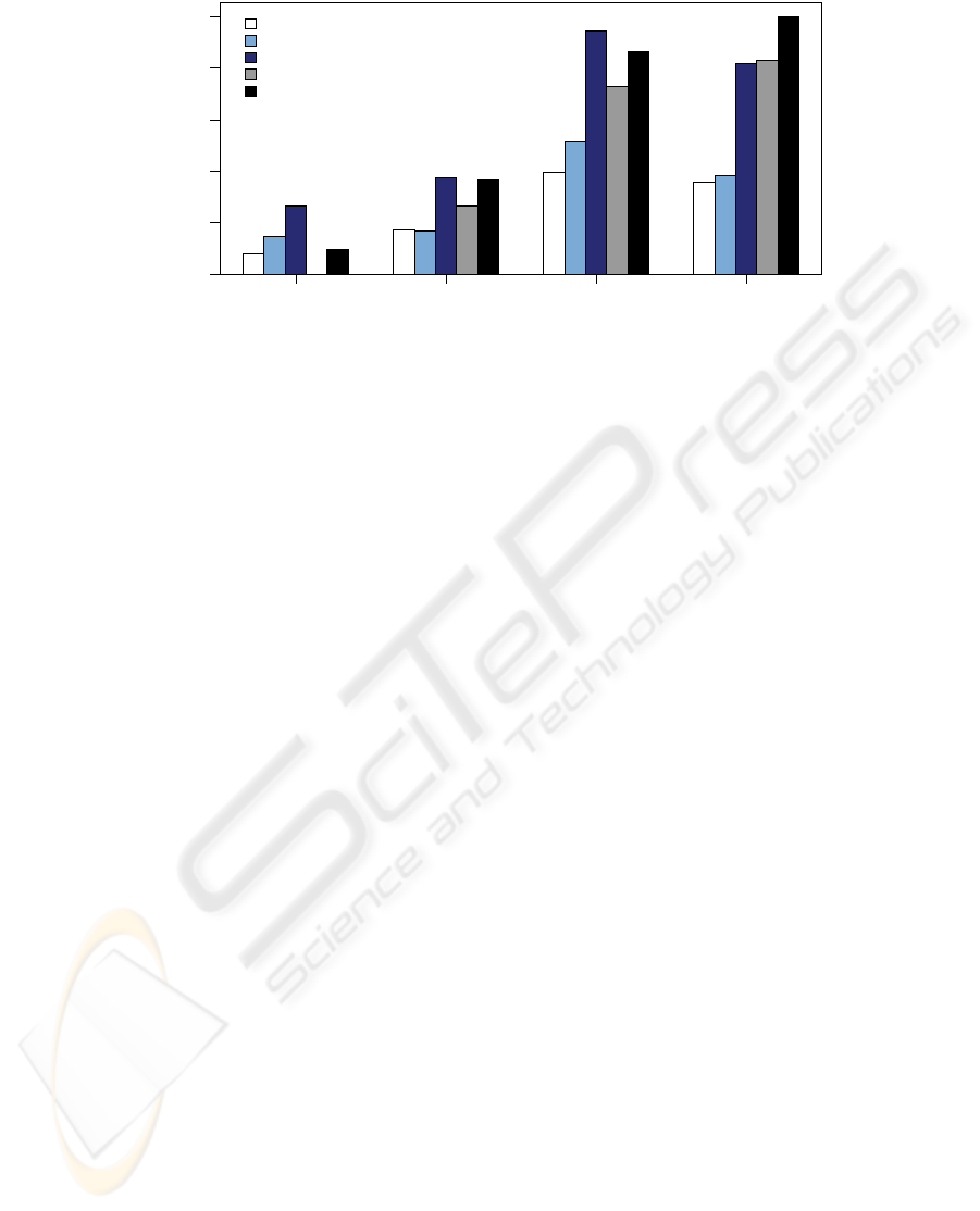
Figure 1 summarizes the number of occurrences
identified through these regular expressions. Be-
tween Q2/2005 and Q1/2006, coverage on 2D and
3D platforms increased significantly by more than
300 and 1,100 percent, respectively (Wilcoxon
Signed Ranks; p<0.05). While in Q2/2005, coverage
on 2D platforms exceeded coverage on their 3D
counterparts (Mann-Whitney; p<0.05), Q1/2006
showed a different picture. There was no significant
difference between the categories, although 3D plat-
forms took a slight lead with an average relative
frequency of exactly one occurrence per million to-
kens. With 83 percent share of coverage, Google
Earth has been the primary driver behind the observ-
able increase in popularity. This represents a re-
markable feat with a product only launched in June
2005, not receiving any mentions in Q2/2005. As of
January 2006, MapQuest still dominated the 2D
category with 46 percent of total coverage, while
Google Maps and Google Local were catching up
rapidly with a share of 44 percent (in the second
quarter of 2005, MapQuest had received nearly
twice as many mentions).
GEOSPATIAL PUBLISHING - Creating and Managing Geo-Tagged Knowledge Repositories
229
05-Q2 05-Q3 05-Q4 06-Q1
0
0.2
0.4
0.6
0.8
1
Occurrences per Million Tokens (Mean)
Google Maps/Local
MapQuest
2D Platforms
Google Earth
3D Platforms
Figure 1: Media Coverage of Geospatial Platforms (Q2/2005 – Q1/2006).
4 CONCLUSION AND OUTLOOK
By integrating traditional cartographic geodata with
geo-tagged hypermedia, the Geospatial Web “may
ultimately be the big disruptive innovation of the
coming decade” (Erle, Gibson, & Walsh, 2005,
xxv). As such, it will serve as a catalyst of social
change and enabler of a broad range of as yet un-
foreseen applications.
The introduction of geo-browsing platforms such
as Google Earth and NASA World Wind has popu-
larized the process of “annotating the Planet” (Udell,
2005). This paper presented the underlying technol-
ogy, methods to “geo-enable” existing knowledge
repositories through parsing and coding geospatial
references, and geospatial applications in a media
context. A quarterly snapshot of international media
coverage revealed the increasing popularity of geo-
spatial products and technologies, particularly as far
as three-dimensional platforms are concerned.
Science and technology’s accelerated advance-
ment demands constant media innovation, from idea
to utility (Stapleton & Hughes, 2006). In this com-
petitive environment, geography is emerging as the
fundamental principle for structuring the Web
(Roush, 2005), yielding the world's knowledge
through the lens of location (Levy, 2004, 58). Geo-
tagging aka adding location metadata to existing
databases and using geo-browsing platforms and
location-based services to access the vast amounts of
information stored in these databases weds physical
and virtual spaces, deepening our experiences of
these spaces and incorporating them into our every-
day lives (Roush, 2005).
ACKNOWLEDGEMENTS
The Know-Center is funded by the Austrian Competence
Center program Kplus under the auspices of the Austrian
Ministry of Transport, Innovation and Technology
(www.ffg.at), and by the State of Styria.
REFERENCES
Abdelmoty, A. I., Smart, P. D., Jones, C. B., Fu, G., &
Finch, D. (2005). A Critical Evaluation of Ontology
Languages for Geographic Information Retrieval on
the Internet. Journal of Visual Languages and Com-
puting, 16(4), 331-358.
Amitay, E., Har’El, N., Sivan, R., & Soffer, A. (2004).
Web-a-Where: Geotagging Web Content. Paper pre-
sented at the 27th Annual International ACM SIGIR
Conference on Research and Development in Informa-
tion Retrieval, Sheffield, UK.
Bell, B. (2006). Vienna Marking Mozart Milestone.
news.bbc.co.uk/2/hi/entertainment/4654880.stm.
Clough, P. (2005). Extracting Metadata for Spatially-
Aware Information Retrieval on the Internet. Paper
presented at the 2nd International Workshop on Geo-
graphic Information Retrieval (GIR-2005), Bremen,
Germany.
Cowie, J., & Lehnert, W. (1996). Information Extraction.
Communications of the ACM, 39(1), 80-91.
Daviel, A., & Kaegi, F. A. (2003). Geographic Registra-
tion of HTML Documents (IETF Internet-Draft, July
2003). Sterling: Internet Engineering Task Force.
Delboni, T. M., Borges, K. A. V., & Laender, A. H. F.
(2005). Geographic Web Search based on Positioning
Expressions. Paper presented at the 2nd International
Workshop on Geographic Information Retrieval (GIR-
2005), Bremen, Germany.
Ding, J., Gravano, L., & Shivakumar, N. (2000). Comput-
ing Geographical Scopes of Web Resources. Paper
ICSOFT 2006 - INTERNATIONAL CONFERENCE ON SOFTWARE AND DATA TECHNOLOGIES
230

presented at the 26th International Conference on
VLDB, Cairo, Egypty.
Erle, S., Gibson, R., & Walsh, J. (2005). Mapping Hacks -
Tips & Tools for Electronic Cartography. Sebastopol:
O'Reilly.
Francica, J. (2005). Struggling for Relevance in the Era of
the Google Phenomenon. Directions Magazine, Dec 1,
2005, http://www.directions-
mag.com/editorials.php?article_id=2035.
Guarino, N. (1997). Understanding, Building and Using
Ontologies. International Journal of Human-
Computer Studies, 46(2-3), 293-310.
Hill, L. L., Frew, J., & Zheng, Q. (1999). Geographic
Names - The Implementation of a Gazetteer in a Geo-
referenced Digital Library. D-Lib Magazine, 5(1),
http://www.dlib.org/.
Hogan, P., & Kim, R. (2004). NASA Planetary Visualiza-
tion Tool. Paper presented at the American Geophysi-
cal Union Fall Meeting, San Francisco, USA.
Horrocks, I., Patel-Schneider, P. F., & Harmelen, F. v.
(2003). From SHIQ and RDF to OWL: The Making of
a Web Ontology Language. Journal of Web Semantics,
1(1), 7-26.
Jones, C. B., Alani, H., & Tudhope, D. (2001). Geo-
graphical Information Retrieval with Ontologies of
Place. In D. R. Montello (Ed.), International Confer-
ence on Spatial Information Theory: Foundations of
Geographic Information Science (= Lecture Notes in
Computer Science, vol. 2205) (pp. 322-335). Berlin:
Springer.
Kendall, J. E. (2005). Satellite Mapping and Its Potential
in Ecommerce: Why We Need Directions to Follow
Our New Maps. Decision Line, 36(5), 11-14.
Kienreich, W., Granitzer, M., & Lux, M. (2006). Geospa-
tial Anchoring of Encyclopedia Articles. Paper pre-
sented at the 10th International Conference on Infor-
mation Visualisation (iV-06), London, UK.
Kutz, D., & Herring, S. C. (2005). Micro-longitudinal
Analysis of Web News Updates. Paper presented at the
38th Hawaii International Conference on System Sci-
ences (HICSS-38), Hawaii, USA.
Lake, R., Burggraf, D., Trninic, M., & Rae, L. (2004).
Geography Mark-Up Language: Foundation for the
Geo-Web. New York: John Wiley & Sons.
Larson, R. R. (1996). Geographic Information Retrieval
and Spatial Browsing. In L. Smith & M. Gluck (Eds.),
GIS and Libraries: Patrons, Maps and Spatial Infor-
mation (pp. 81-124). Urbana-Champaign: University
of Illinois.
Levy, S. (2004). Making the Ultimate Map. Newsweek,
143(23), 56-58.
Liebhold, M. (2004). Infrastructure for the New Geogra-
phy. Menlo Park: Institute for the Future.
McCurley, K. S. (2001). Geospatial Mapping and Naviga-
tion of the Web. Paper presented at the 10th Interna-
tional World Wide Web Conference, Hong Kong,
China.
Morimoto, Y., Aono, M., Houle, M. E., & McCurley, K.
S. (2003). Extracting Spatial Knowledge from the
Web. Paper presented at the Symposium on Applica-
tions and the Internet (SAINT-2003), Orlando, USA.
Pavlik, J. V. (1998). New Media Technology - Cultural
and Commercial Perspectives. Needham Heights: Al-
lyn & Bacon.
Roush, W. (2005). Killer Maps. Technology Review,
108(10), 54-60.
Scharl, A. (2000). Evolutionary Web Development. Lon-
don: Springer. http://webdev.wu-wien.ac.at/.
Scharl, A., Weichselbraun, A., & Liu, W. (2005). An On-
tology-based Architecture for Tracking Information
across Interactive Electronic Environments. Paper
presented at the 39th Hawaii International Conference
on System Sciences (HICSS-39), Kauai, USA.
Smith, M. K., Welty, C., & McGuinness, D. (2004). Web
Ontology Language (OWL) Guide Version 1.0. from
http://www.w3.org/TR/2004/REC-owl-guide-
20040210/
Spohrer, J. (1999). Information in Places. IBM Systems
Journal, 38(4), 602-628.
Stapleton, C., & Hughes, C. E. (2006). Believing is See-
ing: Cultivating Radical Media Innovations. IEEE
Computer Graphics and Applications, 26(1), 88-93.
Tochtermann, K., Riekert, W.-F., Wiest, G., Seggelke, J.,
& Mohaupt-Jahr, B. (1997). Using Semantic, Geo-
graphical, and Temporal Relationships to Enhance
Search and Retrieval in Digital Catalogs. Paper pre-
sented at the 1st European Conference on Research
and Advanced Technology for Digital Libraries (=
Lecture Notes in Computer Science, Vol 1324), Pisa,
Italy.
Udell, J. (2005). Annotating the Planet with Google Maps.
InfoWorld, March 04, 2005,
http://www.infoworld.com/article/05/03/04/10OPstrat
egic_01.html.
Wang, C., Xie, X., Wang, L., Lu, Y., & Ma, W.-Y. (2005).
Detecting Geographic Locations from Web Resources.
Paper presented at the 2nd International Workshop on
Geographic Information Retrieval (GIR-2005), Bre-
men, Germany.
Wilk, C. (2005). Welt in Händen: Arbeiten mit Google
Earth und World Wind. iX - Magazin für
professionelle Informationstechnik, 12/05, 50-62.
GEOSPATIAL PUBLISHING - Creating and Managing Geo-Tagged Knowledge Repositories
231
